- This article is about the river that empties into the Gulf of Mexico. See Wikipedia:Rio Grande (disambiguation) and Wikipedia:Río Bravo (disambiguation) for other meanings. See Rio Grande (Jamaica)
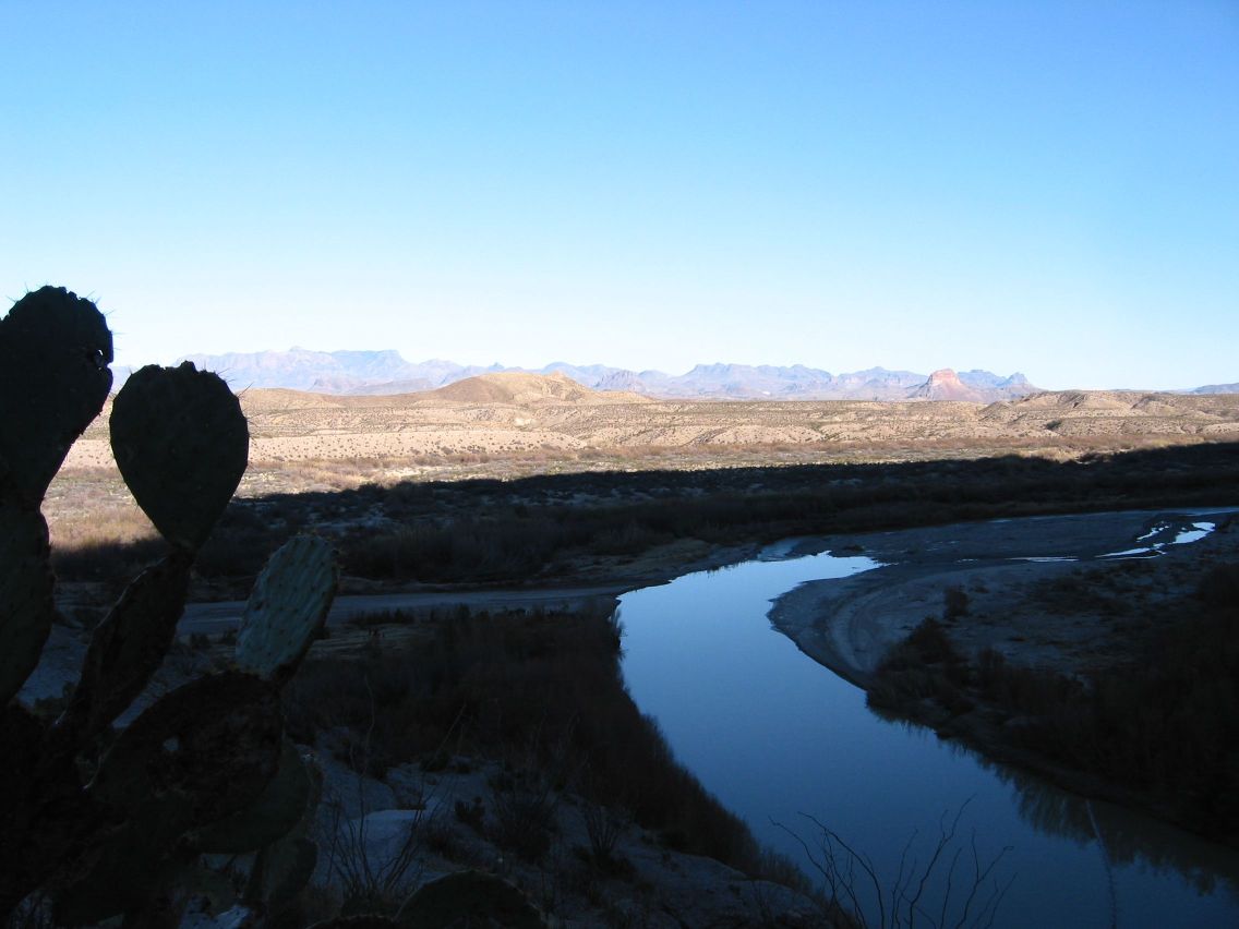
The Rio Grande flowing in Big Bend National Park
Known as the Rio Grande (or the redundant Rio Grande River) in the United States and as the Río Bravo (or, more formally, the Río Bravo del Norte) in Mexico, the river, 3034 km long, rises in the San Juan Mountains of Colorado, USA, flows through the San Luis Valley, then south into New Mexico through Albuquerque and Las Cruces to El Paso, Texas, on the U.S.–Mexico border. A major tributary, Rio Conchos, enters at Presidio, below El Paso and supplies most of the water in the 1000 miles Texas border segment. The watershed of the Rio Grande is called the Rio Grande Basin. The headwaters region in Colorado may be called the Rio Grande Basin in Colorado.
The river has, since 1845, marked the boundary between Mexico and the United States from the twin cities of El Paso, Texas, and Ciudad Juárez, Chihuahua, to the Gulf of Mexico. As such, it was across this river that Texan slaves fled when seeking their freedom, aided by Mexico's liberal colonization policies and abolitionist stance. (See [1] (PDF).)
The major international border crossings along the river are Ciudad Juárez and El Paso; Laredo, Texas, and Nuevo Laredo, Tamaulipas; McAllen-Hidalgo, Texas, and Reynosa, Tamaulipas; and Brownsville, Texas, and Matamoros, Tamaulipas. Other notable border towns are the Texas/Coahuila pairings of Del Rio–Ciudad Acuña and Eagle Pass–Piedras Negras.
The US and Mexico share the waters of this river under a series of agreements administered by the joint US-Mexico Boundary and Water Commission.
Use of that belonging to the US is regulated by the Rio Grande Compact, an interstate compact between Colorado, New Mexico and Texas. The Rio Grande is over-appropriated, that is, there are more users for the water than there is water in the river. In times of servere drought the section from El Paso downstream through Big Bend National Park has been dry. Ecologists fear that unless rainfall returns to normal levels during the next few years and strict water conservation measures are adopted by communities along the river, the Rio Grande may soon become extinct.
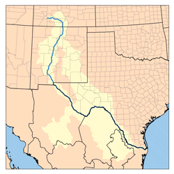
Map of the Rio Grande Watershed
The Rio Grande rises in high mountains and flows for much of its length at high elevation; El Paso is 1147 m (3762 feet) above sea level. In New Mexico the river flows through the Rio Grande Rift from one sediment-filled basin to another, cutting canyons between the basins and supporting a fragile bosque ecosystem in its floodplain. From El Paso eastward the river flows through desert. Only in the sub-tropical lower Rio Grande Valley is there extensive irrigated agriculture. The river ends in a small sandy delta at the Gulf of Mexico. During periods of extended dry weather, the river will actually cease flowing into the Gulf.
Millions of years ago, the Rio Grande ended at the bottom of the Rio Grande Rift in Lake Cabeza de Vaca. But about 1 million years ago the stream was "captured" and began to flow east.
Further Reading[]
- Paul Horgan, Great River: The Rio Grande in North American History. Vol. 1, Indians and Spain. Vol. 2, Mexico and the United States. 2 Vols. in 1, 1038 pages - Wesleyan University Press 1991, 4th Reprint, ISBN 0819562513
See also[]
- List of Colorado rivers
- List of New Mexico rivers
- List of Texas rivers
External links and further reading[]
- "The History and Development of the Rio Grande River In the Albuquerque Region" course materials by Doug Earick on the website of the University of New Mexico
- Map of the Rio Grande basin in Water Resources eAtlas
- Article on the Rio Grande in the Handbook of Texas Online
- Coping with scarcity in the Río Grande/Río Bravo drainage basin: lessons to be learned from the droughts of 1993-1996. (1999). Natural resources journal, vol. 39, no. 1. Albuquerque, N.M.: University of New Mexico School of Law. OCLC 60449040
References[]
- This article was adapted from the Wikipedia article, "Rio Grande" http://en.wikipedia.org/wiki/Rio_Grande