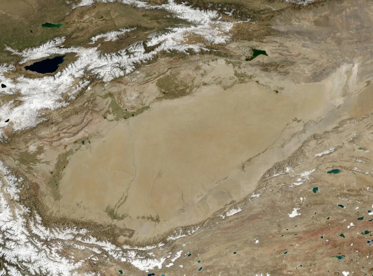
NASA photo of the endorheic Tarim Basin
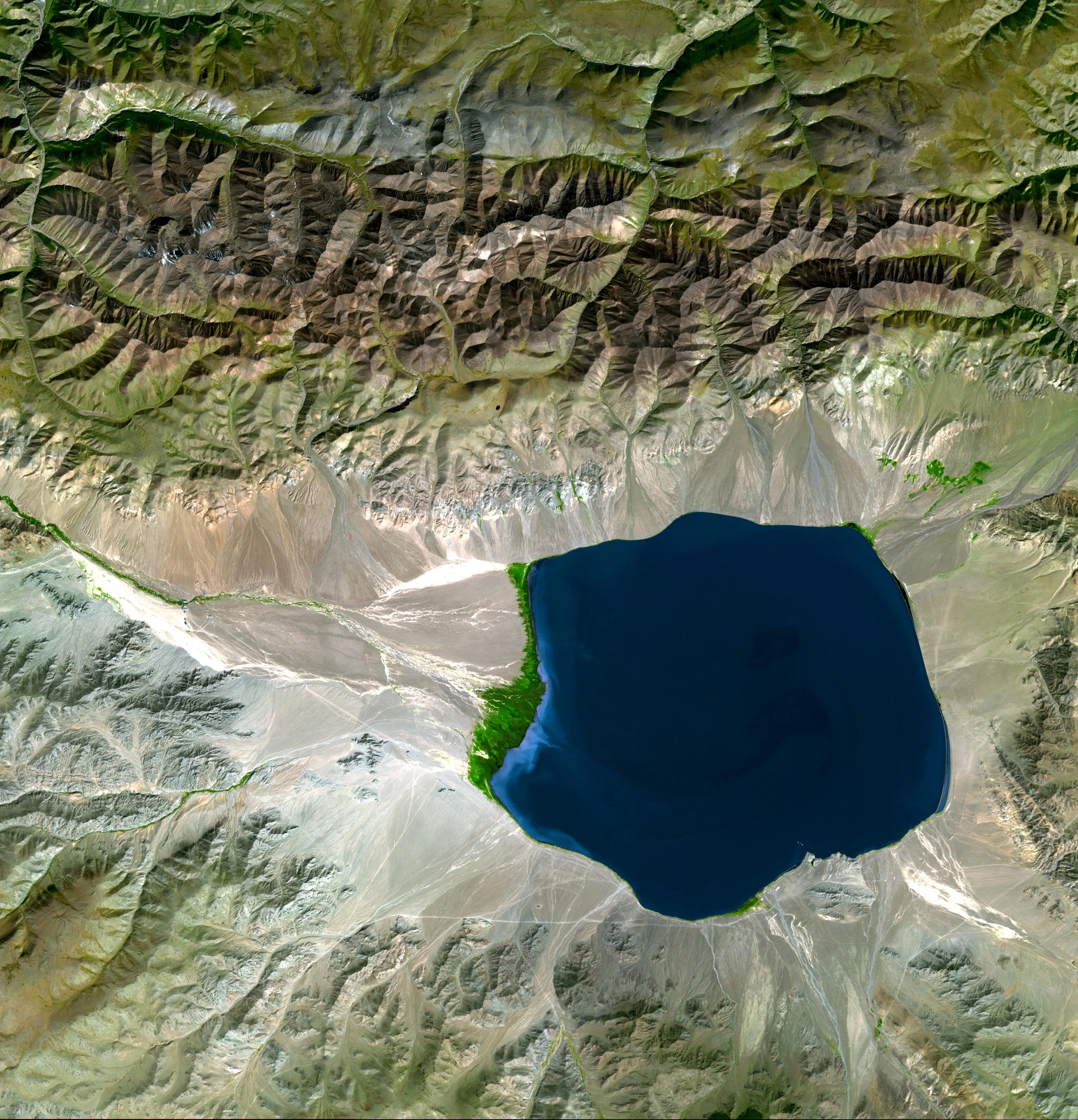
Endorheic basin showing waterflow input into Üüreg Lake
An endorheic basin (from the Greek ἔνδον, éndon, "within" and Greek ῥεῖν rheîn, "to flow") is a closed drainage basin that retains water and allows no outflow to other external bodies of water, such as rivers or oceans, but converges instead into lakes or swamps, permanent or seasonal, that equilibrate through evaporation. Such basins may also be referred to as closed or terminal basin or as internal drainage systems.
Normally, water that has accrued in a drainage basin eventually flows out through rivers or streams on the Earth's surface or by underground diffusion through permeable rock, ultimately ending up in the oceans. However, in an endorheic basin, rain (or other precipitation) that falls within it does not flow out but may only leave the drainage system by evaporation and seepage. The bottom of such a basin is typically occupied by a salt lake or salt pan.
Endorheic regions, in contrast to exorheic regions which flow to the ocean in geologically defined patterns, are closed hydrologic systems. Their surface waters drain to inland terminal locations where the water evaporates or seeps into the ground, having no access to discharge into the sea.[1] Endorheic water bodies include some of the largest lakes in the world, such as the Aral Sea and the Caspian Sea, the world's largest saline body of water cut off from the ocean.[2]
Endorheic lakes[]
Endorheic lakes are bodies of water that do not flow into the sea. Most of the water falling on Earth finds its way to the oceans through a network of rivers, lakes and wetlands. However, there is a class of water bodies that are located in closed or endorheic watersheds where the topography prevents their drainage to the oceans. These endorheic watersheds (containing water in rivers or lakes that form a balance of surface inflows, evaporation and seepage) are often called terminal lakes or sink lakes.[3]
Endorheic lakes are usually in the interior of a body mass, far from an ocean. Their watersheds are often confined by natural geologic land formations such as a mountain range, cutting off water egress to the ocean. The inland water flows into dry watersheds where the water evaporates, leaving a high concentration of minerals and other inflow erosion products. Over time this input of erosion products can cause the endorheic lake to become relatively saline (a "salt lake"). Since the main outflow pathways of these lakes are chiefly through evaporation and seepage, endorheic lakes are usually more sensitive to environmental pollutants inputs than water bodies that have access to oceans.[2]
Occurrence[]
Endorheic regions can occur in any climate but are most commonly found in desert locations. In areas where rainfall is higher, riparian erosion will generally carve drainage channels (particularly in times of flood), or cause the water level in the terminal lake to rise until it finds an outlet, breaking the enclosed endorheic hydrological system's geographical barrier and opening it to the surrounding terrain. The Black Sea was likely such a lake, having once been an independent hydrological system before the Mediterranean Sea broke through the terrain separating the two.
Endorheic regions tend to be far inland with their boundaries defined by mountains or other geological features that block their access to oceans. Since the inflowing water can evacuate only through seepage or evaporation, dried minerals or other products collect in the basin, eventually making the water saline and also making the basin vulnerable to pollution.[2] Continents vary in their concentration of endorheic regions due to conditions of geography and climate. Australia has the highest percentage of endorheic regions at 21 percent while North America has the least at 5 percent.[4] Approximately 18 percent of the earth's land drains to endorheic lakes or seas, the largest of these land areas being the interior of Asia.
In deserts, water inflow is low and loss to solar evaporation high, drastically reducing the formation of complete drainage systems. Closed water flow areas often lead to the concentration of salts and other minerals in the basin. Minerals leached from the surrounding rocks are deposited in the basin, and left behind when the water evaporates. Thus endorheic basins often contain extensive salt pans (also called salt flats, salt lakes, alkali flats, dry lake beds or playas). These areas tend to be large, flat hardened surfaces and are sometimes used for aviation runways or land speed record attempts, because of their extensive areas of perfectly level terrain.
Both permanent and seasonal endorheic lakes can form in endorheic basins. Some endorheic basins are essentially stable, climate change having reduced precipitation to the degree that a lake no longer forms. Even most permanent endorheic lakes change size and shape dramatically over time, often becoming much smaller or breaking into several smaller parts during the dry season. As humans have expanded into previously uninhabitable desert areas, the river systems that feed many endorheic lakes have been altered by the construction of dams and aqueducts. As a result many endorheic lakes in developed or developing countries have contracted dramatically, resulting in increased salinity, higher concentrations of pollutants, and the disruption of ecosystems.
Even within exorheic basins, there can be "non-contributing", low-lying areas that trap runoff and prevent it from contributing to flows downstream during years of average or below-average runoff. In flat river basins, non-contributing areas can be a large fraction of the river basin. (E.g. Lake Winnipeg's basin)[5]
Notable endorheic basins and lakes[]
See also List of endorheic basins.
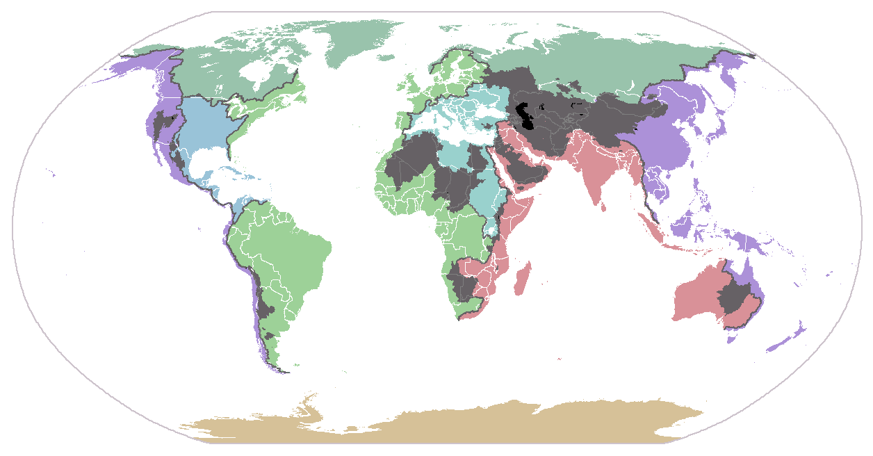
Major endorheic basins of the world. Basins are shown in dark gray; major endorheic lakes are shown in black. Colored regions represent the major drainage patterns of the continents to the oceans (non-endorheic). Continental divides are indicated by dark lines.
Asia[]
Caspian Sea, a giant inland basin
Lake Van, Turkey
Much of western and Central Asia is a giant endorheic region made up of a number of contiguous closed basins. The region contains several basins and terminal lakes, including:
- The Caspian Sea, the largest lake on Earth. A large part of Eastern Europe, drained by the Volga River, is part of the Caspian's basin.
- Lake Urmia in Western Azerbaijan Province of Iran.
- The Aral Sea, whose tributary rivers have been diverted, leading to a dramatic shrinkage of the lake. The resulting ecological disaster has brought the plight faced by internal drainage basins to public attention.
- Lake Balkhash, in Kazakhstan.
- Issyk-Kul Lake, Son-Kul Lake, and Chatyr-Kul Lake in Kyrgyzstan.
- Lop Lake, in the Tarim Basin of China's Xinjiang Uygur Autonomous Region.
- The Central Asian Internal Drainage Basin, in southern and western Mongolia, contains a series of closed drainage basins, such as the Khyargas Nuur basin, the Uvs Nuur basin, and the Pu-Lun-To River Basin.[6]
- Qaidam Basin, in Qinghai Province, China.
- Sistan Basin covering areas of Iran and Afghanistan
- Pangong Tso on the Indo-Chinese border
Other endorheic lakes and basins in Asia include:
- The Dead Sea, the lowest surface point on Earth and one of its saltiest bodies of water, lies between Israel and Jordan.
- Sambhar Lake, in Rajasthan, north-western India, is the terminal point of an endorheic basin.
- Lake Van, in Turkey, is one of the world's largest endorheic lakes.
- Sabkhat al-Jabbul, extensive salt flats and a 100 square kilometres (Template:Convert/sqmi) lake in Syria.
- Solar Lake, Sinai, near the Israeli-Egypt border.
- Lake Tuz, in Turkey, in south part of Central Anatolia Region
Australia[]
A false-colour satellite photo of Australia's Lake Eyre
Image credit: NASA's Earth Observatory
Australia, being very dry and having exceedingly low runoff ratios due to its ancient soils, has many endorheic drainages. The most important are:
- Lake Eyre Basin, which drains into the highly variable Lake Eyre and includes Lake Frome.
- Lake Torrens, to the west of the Flinders Ranges in South Australia.
- Lake Corangamite, a highly saline crater lake in western Victoria.
- Lake George, formerly connected to the Murray-Darling Basin
Africa[]
Large endorheic regions in Africa are located in the Sahara Desert, the Kalahari Desert, and the East African Rift:
- Chad Basin, in the northern center of Africa. It covers an area of approximately 2.434 million km².
- Qattara Depression, in Egypt.
- Chott Melrhir, in Algeria.
- Chott el Djerid, in Tunisia.
- The Okavango River, in the Kalahari Desert, is part of an endorheic basin region which also includes the Okavango Delta, Lake Ngami, the Nata River, and a number of salt pans such as Makgadikgadi Pan.
- Etosha pan in Namibia's Etosha National Park.
- Lake Turkana, in Kenya, whose basin includes the Omo River of Ethiopia.
- Lake Chilwa, in Malawi.
- Afar Depression, in Eritrea, Ethiopia, and Djibouti.
- Some Rift Valley lakes, such as Lake Abijatta, Lake Chew Bahir, Lake Shala, Lake Chamo, and Lake Awasa.
- Lake Mweru Wantipa, in Zambia.
North and Central America[]
The dry lake at Badwater in Death Valley National Park.
Great Salt Lake, Satellite photo (2003) after five years of drought
- The Valley of Mexico. In Pre-Columbian times, the Valley was substantially covered with five lakes, including Lake Texcoco, Lake Xochimilco, and Lake Chalco.
- Guzmán Basin, in northern Mexico and the southwestern United States. The Mimbres River of New Mexico drains into this basin.
- Lago de Atitlán, in the highlands of Guatemala.
- Lago de Coatepeque, El Salvador.
- Bolsón de Mapimí, in northern Mexico.
- Willcox Playa of southern Arizona.
- The Great Basin,[7] which covers much of Nevada, Oregon and Utah, is a large region of contiguous closed basins, including:
- Great Salt Lake, in Utah, the largest terminal lake in the Western Hemisphere.
- The Black Rock Desert in Nevada, location of the Thrust2 and ThrustSSC landspeed record runs, and the annual home to the Burning Man festival.
- Death Valley, the lowest land point in the United States. During the Holocene epoch, Lake Manly filled the Death Valley basin of Inyo County, California. Later, Death Valley had a system of tributary basins:
- Rogers Dry Lake, within the Edwards Air Force Base in California.
- Owens Lake and the Owens River basin.
- Mono Lake in California.
- Groom Dry Lake in Nevada, location of Area 51.
- Abert Lake and Summer Lake in Oregon.
- Goose Lake (Oregon-California) on the California/Oregon border. Historically it drained into the Pit River. Agricultural development and irrigation diversions have lowered the lake level so that it no longer drains to the sea.
- Malheur Lake in Oregon.
- Warner Valley in Oregon.
- Alvord Desert in Oregon.
- Salton Sea in California, a lake accidentally recreated in 1905 when irrigation canals ruptured, filling the desert Salton Sink recreating Lake Cahuilla an ancient saline sea.
- Lake Elsinore in California and the San Jacinto River. Intermittently drains into the Santa Ana River.
- Sevier Lake, in Utah.
- Pyramid Lake in Nevada, whose drainage basin includes Lake Tahoe.
- Humboldt Sink and the Humboldt River basin in Nevada.
- Carson Sink and the Carson River basin in Nevada.
- Walker Lake and the Walker River in Nevada.
- Tulare Lake in the southern end of the San Joaquin Valley fed by the Kaweah and Tule Rivers plus southern distributaries of the Kings. Historically, in very wet years it would drain into the San Joaquin River. Agricultural development and irrigation diversions have left the lake dry.
- Buena Vista Lake at the southmost end of the San Joaquin Valley fed by the Kern River. Historically, in exceptionally wet years it would drain into Tulare Lake and then into the San Joaquin River. Agricultural development and irrigation diversions have left the lake dry.
- Crater Lake, in Oregon.
- The Great Divide Basin in Wyoming, a small endorheic basin that straddles the Continental Divide of the Americas.
- Devils Lake, in North Dakota.
- Devil's Lake, in Wisconsin.
- Little Manitou Lake in Saskatchewan.
- Old Wives Lake, on the Laurentian Divide in Saskatchewan.
- Pakowki Lake, on the Laurentian Divide in Alberta.
- New Mexico has a number of desert endorheic basins including:
- The Tularosa Basin, a rift valley.
- Zuni Salt Lake, a maar.
- The Mimbres River Basin, in Grant County.
- Lago Enriquillo on the island of Hispaniola in the Caribbean Sea.
Many small lakes and ponds in North Dakota and Manitoba are endorheic; some of them have salt encrustations along their shores.
Europe[]
The Lasithi Plateau in Crete
Though a large portion of Europe (about 19%, located in Russia and Kazakhstan) drains to the endorheic Caspian Sea, Western Europe contains relatively few terminal lakes: any such basin is likely to continue to fill until it reaches an overflow level connecting it with an outlet or erodes the barrier blocking its exit. Exceptions include:
- Lake Neusiedl, in Austria and Hungary.
- Lake Trasimeno, in Italy.
- Lake Velence, in Hungary.
- Lake Prespa, between Albania, Greece and the Republic of Macedonia.
- Rahasane turlough, the largest turlough in Ireland.
- Laacher See, in Germany.
- The Lasithi Plateau in Crete, Greece, is a high endorheic plateau.
All these lakes are drained, however, either through manmade canals or via karstic phenomena. Minor additional endorheic lakes exist throughout the Mediterranean countries Spain (e.g. Laguna de Gallocanta, Estany de Banyoles), Italy, Cyprus (Larnaca and Akrotiri salt lakes) and Greece.
South America[]
MODIS image from November 4, 2001 showing Lake Titicaca, the Salar de Uyuni, and the Salar de Coipasa. These are all parts of the Altiplano
- Laguna del Carbón, in Gran Bajo de San Julián, Argentina - the lowest point in the Western and Southern hemispheres
- The Altiplano includes a number of closed basins such as Poopó Lake.
- Lake Valencia, in Venezuela.
- Salar de Atacama, in the Atacama Desert, Chile.
Ancient[]
Some of the Earth's ancient endorheic systems and lakes include:
- The Black Sea, until its merger with the Mediterranean.
- The Mediterranean Sea itself and all its tributary basins, during its Messinian desiccation (5 m.y. BP approx.) as it became disconnected from the Atlantic Ocean.
- Lake Tanganyika in Africa. Currently high enough to connect to rivers entering the sea.
- Lake Lahontan in North America.
- Lake Bonneville in North America.
- Lake Chewaucan in North America.
- Tularosa Basin and Lake Cabeza de Vaca in North America. Basin formerly much larger than at present, including the ancestral Rio Grande north of Texas, feeding a large lake area.
- Ebro and Duero basins, draining most of northern Spain during the Neogene and perhaps Pliocene.
See also[]
- List of endorheic basins
References[]
- ↑ Drainage systems. Encyclopædia Britannica. Retrieved on 2008-02-11.
- ↑ 2.0 2.1 2.2 Endorheic Lakes: Waterbodies That Don't Flow to the Sea. United Nations Environment Programme. Retrieved on 2008-02-11.
- ↑ What is a watershed and why should I care?. university of delaware. Retrieved on 2008-02-11.
- ↑ (1986-04-30) Saline Lake Ecosystems of the World. Springer. Retrieved on 2007-07-31.
- ↑ http://www.gov.mb.ca/waterstewardship/water_quality/state_lk_winnipeg_report/pdf/state_of_lake_winnipeg_rpt_technical_high_resolution.pdf, p 2.
- ↑ Basins. Mongolian River Resources. Retrieved on 21 November 2010.
- ↑ Houghton, Samuel G. (1994). A trace of desert waters: the Great Basin story. Reno: University of Nevada Press.
External links[]
- Primer on endorheic lakes
- The Silk Roads and Eurasian Geography
- The role of climate during high plateau formation. Insights from numerical experiments
Template:List of seas

|
This page uses content from Wikipedia. The original article was at Endorheic basin. The list of authors can be seen in the page history. As with WaterWiki, the text of Wikipedia is available under the Creative Commons Attribution-Share Alike License 3.0 (Unported) (CC-BY-SA). |