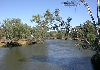
The Murray River in Australia.
A river is a large natural flowing waterway. The source of a river may be a lake, a spring, or a collection of small streams, known as headwaters. From their source, all rivers flow downhill, typically terminating in the ocean. The mouth, or lower end of a river is known as its base level. A river's water is normally confined to a channel, made up of a stream bed between banks. Most rainfall on land passes through a river on its way to the ocean. Smaller side streams that join a river are tributaries. The scientific term for any flowing natural waterway is a stream; so in technical language, the term river is just a shorthand way to refer to a large stream.
Topography[]
A river conducts water by constantly flowing perpendicular to the elevation curve of its bed, thereby converting the positional energy of the water into kinetic energy. Where a river flows over relatively flat areas, the river will meander: start to form loops and snake through the plain by eroding the river banks. Sometimes the river will cut off a loop, shortening the channel and forming an oxbow lake from the cut off section. Rivers that carry large amounts of sediment develop conspicuous deltas at their mouths. Rivers whose mouths are in saline tidal waters may form estuaries.
Over time, rivers cut away at their beds, eventually forming a more gradual gradient.
There are 4 main types of rivers. These types are:
- Youthful river - a river with a steep gradient that has very few tributaries and flows quickly. Its channels erode deeper rather than wider.
- Mature river - a river with a gradient that is less steep than those of youthful rivers and flows more slowly than youthful rivers. A mature river is fed by many tributaries and has more discharge than a youthful river. Its channels erode wider rather than deeper.
- Old river - a river with a low gradient and low erosive energy. Old rivers are characterized by flood plains.
- Rejuvenated river - a river with a gradient that is raised by the earth's movement.
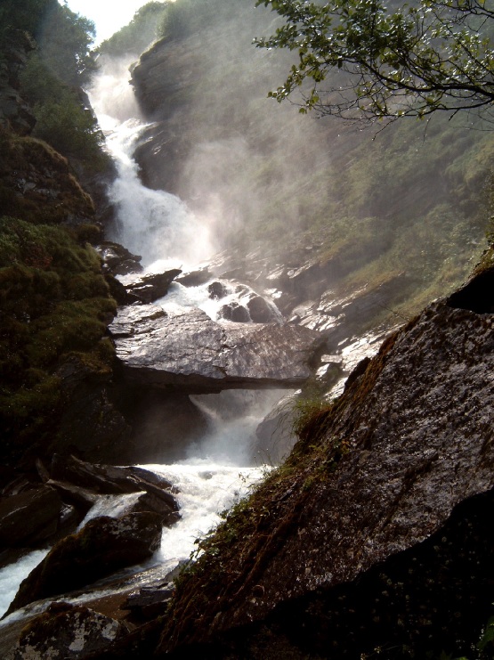
A waterfall on the Ova da Fedoz, Switzerland.
Where a river descends quickly over sloped topography, rapids with whitewater or even waterfalls occur. Rapids are often used for recreational purposes (see Whitewater kayaking). Waterfalls are sometimes used as sources of energy, via watermills and hydroelectric plants.
Rivers begin at their source in higher ground, either rising from a spring, forming from glacial meltwater, flowing from a body of water such as a lake, or simply from damp, boggy places where the soil is waterlogged. They end at their base level where they flow into a larger body of water, the sea, a lake, or as a tributary to another (usually larger) river. In arid areas rivers sometimes end by losing water to evaporation and percolation into dry, porous material such as sand, soil, or pervious rock. The area drained by a river and its tributaries is called its watershed or catchment basin. (Watershed is also used however to mean a boundary between catchment basins.)
Starting at the mouth of the river and following it upstream as it branches again and again the resulting river network forms a dendritic (tree-like) structure that is an example of a natural random fractal.
Biology[]
The flora and fauna of rivers are much different from those of the ocean because the water is fresh (non-salty). Living things in a river must be adapted to the current of the moving water.
Pollution[]
Human pollution of rivers is common, and very few rivers in the world today are clean of man-made substances. The most common point source of pollutant is probably sewage piped into rivers, but chemical pollution is also common, and industrial accidents (and/or negligence) account for significant destruction of riparian biomes. Heated water dumped into rivers by power plants and factories also affects river life. Non-point source pollutants such as diffuse pollution from agriculture, urbanisation and forestry and now being recognised as one of the more damaging sources of pollutants in the developed world.
[]
The Rhine River is the busiest river in the world for transport ships. Inland vessels use the river to reach the major cities in Germany, Eastern France and Switzerland to transport bulk goods, liquids, containers AND passengers into the hinterland of the Port of Rotterdam and the ports of Amsterdam and Antwerp. Many millions of tons of goods are transported upstream yearly from these three sea ports to the industries near Nijmegen, Duisburg, Düsseldorf, Neuss, Köln, Koblenz, Mainz, Mannheim, Karlsruhe, Strasbourg, Colmar, Mulhouse and Basel.
The lower part of the river is navigable for the largest inland vessels (up to 135 meters long and 17 meters wide) with an available depth of more than 2,50 even at the lower water levels. The further upstream, the more depth restrictions: at low water periods draught of ships is often limited to 1,90 m. for the stretch around Bingen (between the mouths of the Mosel and the Main).
Upstream from Karlsruhe the Rhine River is the border between France and Germany. The French have canalized the river by means of a series of hydropower dams and double ship locks, thus ensuring a year round navigable depth of 3.50 meters. (Source: NoorderSoft Waterways Database)
Dams[]
In places where the elevation changes of a river are great, dams for hydroelectric plants and other purposes are often built. This disrupts the natural flow of the river, and creates a lake behind the dam. Often the building of dams affects the whole of the river, even the part above the dam, as migrating fish are hindered (see fish ladder), waterflow is no longer bounded by seasonal changes and sediment flow is blocked. Dams are useful in many ways, such as providing HEP, acting as regulator of river flow so as to regulate the occurrence of flooding, which is especially important to wet-rice agriculture, and also to improve navigation and transport on the river. Often, dams such as Hoover Dam along Colorado River become famous tourist attractions. Critics of dams especially 'Green' advocates, argue that dams remove upper-river biodiversity such as through deforestation and forced migration of rural villages and indigenous tribes. Furthermore, trapping of river sediments behind the dams lead to salination and loss of nutrients for down-water fish. It also raises concern of eathquakes due to instablity of incompetent dams which have to support thousands of tonnes of sediments behind them. One very famous, and problematic, dam is the Aswan High Dam in the Nile.
Flooding[]
Flooding is a natural part of a river's cycles. Human activity, however, has upset the natural way flooding occurs by walling off rivers and straightening their courses. Removal of bogs, swamps and other wetlands in order to produce farmland has reduced the absorption zones for excess water and made floods into sudden disasters rather than gradual increases in water flow. In ancient Egypt, life was made possible through the floods of the Nile and the accompanying silt and sediment which enriched the fields with fresh nutrients. Nowadays, since people have built on these floodplains, floods are disasters, causing untold property loss each year.
Human interference in the form of deforestation can also worsen conditions. The removal of vegetation leads to a reduction in intercepting (vegetation stopping precipitation) and the 'weakening' of soil since plant roots no longer hold it together. As a result there is a reduced Infiltration capacity (how much water the soil can hold) and greater infiltration (precipitation going into the ground). This leads to faster soil saturation and therefore greater overland flow (also known as surface run off) and therefore, there are flash floods as the lag time decrease.
Logjams[]
Logjams are barriers within rivers, created by dead and uprooted trees. Over time, the obstruction prevents further logs to bypass, resulting in the creation of new network channels. According to author David R. Montgomery in his book, King of Fish, a logjam also causes water to buildup within a small space, forming peaceful pools within the main channel for young salmon to live within. The existence of these deep pools along with the complex web of channels creates an ideal salmon habitat. Today, many believe that the rebuilding of salmon runs is contingent upon reproducing the same environment shaped by logjams. As a result, many scientists have attempted to recreate artificial logjams. Marc Duboiski and Mike Ramsey of the Salmon Recovery Funding board staff, George Pess of the National Marine Fisheries Service, and Kevin Bauersfeld of Washington Department of Fish and Wildlife have prepared the Report to the Salmon Recovery Funding Board On the Engineered Log Jam (ELJ) Workshop ([1]), with the hope of mimicking natural logjams.
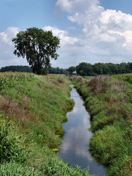
Small river in rural Indiana. Rivers of this size are often referred to as a "creek."
Management[]
In its natural state a river may be inconvenient to man in a variety of ways. Rivers in inhabited areas have therefore been managed or controlled to make them more useful and less disruptive to human activity.
- The river channel may be dredged to make it deeper for navigation or to prevent flooding.
- Dams (see above) or weirs may be built to control the flow, store water, or extract energy.
- Levees may be built to prevent flooding.
- Sluice gates provide a means of controlling flow and adjusting river levels.
- floodways may be added to draw off excess river water in times of flood.
- Canals connect rivers to one another for water transfer or navigation.
- River courses may be modified to improve navigation, or straightened to increase the flow rate.
River management is an ongoing activity as rivers tend to 'undo' the modifications made by man. Dredged channels silt up, sluice mechanisms deteriorate with age, levees and dams may suffer seepage or catastrophic failure.
River lists[]
The world's ten longest rivers[]
It is difficult to measure the length of a river, mainly because rivers have a fractal property, which means that the more precise the measure, the longer the river will seem. Also, it's hard to state exactly where a river begins or ends, as very often, upstream, rivers are formed by seasonal streams, swamps, or changing lakes.
This is an average measurement.
- Nile (6,690 km)
- Amazon (6,400 km)
- Yangtze (Chang Jiang) (6,380 km)
- Mississippi-Missouri (6,270 km)
- Ob-Irtysh (5,570 km)
- Huang He (Yellow) (5,464 km)
- Amur (4,410 km)
- Congo (4,380 km or 4,670 km). (The source of this river is disputed.)
- Lena (4,260 km)
- Mackenzie (4,240 km)
For a longer list see Longest rivers. This also gives more information on measuring river lengths.
Well-known rivers (in alphabetic order)[]
- Amazon - largest river in the world
- American
- Amu Darya
- Amur - principal river of eastern Siberia and boarder river Russia/China
- Arkansas - major tributary of Mississippi River
- Arno - river through Florence
- Arvandrud (Shatt al-Arab) the large border river between Iran and Iraq.
- Brahmaputra - principal river in North East India & Tibet
- Chao Phraya - principal river of Thailand
- Colorado (Argentina)
- Colorado (U.S.) - principal river of American West
- Columbia - principal river of Pacific Northwest
- Copper River - major river of Alaska
- Congo - principal river of central Africa
- Danube - principal river of central and southeastern Europe
- De La Plata - the widest river in the world. South America
- Ebro - river in northwest Spain
- Elbe - major German river, Hamburg is situated on it
- Euphrates - twin principal river of Mesopotamia(Iraq)
- Ganges - principal river of India
- Han-gang - river of Seoul
- Helmand River - Principle river of (Afghanistan)
- Hari Rud (Afghanistan)
- Huang He (Yellow) - principal river of China
- Hudson - principal river of New York
- Indus - principal river of Pakistan
- Jordan - principal river of Israel
- Karun - principal (navigable) river of southern Iran.
- Kaveri - principal river of South India
- Lena - principal river of northeastern Siberia
- Mackenzie - longest river in Canada
- Magdalena - principal river of Colombia
- Main - river in Germany
- Mekong - principal river of Southeast Asia
- Mersey - river on which sits the English city of Liverpool
- Meuse - principal river of the southern provinces of the Netherlands and eastern Belgium.
- Mississippi - principal river of central United States
- Missouri - principal river of the Great Plains
- Murray - principal river of southeastern Australia
- Niger - principal river of west Africa
- Nile - Possibly the longest river in the world (or second after the Amazon)
- Ob - large river of Siberia
- Odra - major river in Eastern Europe
- Ohio - largest river between Mississippi and Appalachians
- Orinoco - principal river of Venezuela
- Parana - major South American river
- Paraguay - principal tributary of Parana river and major South American river in Brazil, Bolivia, Paraguay and Argentina
- Po - principal river of Italy
- Potomac River - principal river of the District of Columbia in the United States
- Rhine River - principal river of northwestern Europe
- Rhône - principal river of southern France
- Rio Grande - border between United States and Mexico
- Saint Lawrence - drains Great Lakes
- Seine - river of Paris
- Segura- in southeast Spain
- Severn- longest river in Great Britain
- Shinano-gawa - longest river in Japan
- Snake - largest tributary to the Columbia river in Washington
- Tajo - largest river in the Iberian Peninsula
- Tay - largest river in Scotland
- Thames - river of London
- Tiber - river of Rome
- Tigris - twin principal river of Mesopotamia(Iraq)
- Tonegawa - largest river in Japan
- Vistula - principal river of Poland
- Vltava - river of Prague
- Volga - principal river of Russia
- Yangtze (Chang Jiang) - longest river in China
- Yenisei - large river of Siberia
- Yukon - principal river of Alaska and Yukon Territory
- Zambezi - principal river of southeastern Africa
Other lists[]
- List of waterways
- List of rivers by continent
- List of rivers of Europe
- Rivers of the United Kingdom
- List of rivers of Asia
- List of rivers of Africa
- List of rivers of Antarctica
- List of rivers of Australia
- List of rivers of New Zealand
- List of rivers of the Americas
- List of rivers of Oceania
- List of rivers of Europe
- List of river name etymologies
See also[]
- Aquaduct
- Canal
- Drought
- Water dispute
Crossings[]
Rivers may be crossed by:
- bridges
- ferries
- fords
- tunnels.
Transport[]
- barge
- riverboat
- sailing
- towpath
Further reading[]
- Luna B. Leopold, A View of the River, Harvard University Press (1994), hardcover, 298 pages, ISBN 0674937325 A non-technical primer on the geomorphology and hydraulics of the river. Luna B. Leopold, Emeritus Professor of Geology at the University of California was Chief Hydrologist for the U.S. Geological Survey. Measurements are in traditional English units.
External links[]
Adapted from the Wikipedia article, "River" http://en.wikipedia.org/wiki/River